ST. GEORGE — The National Weather Service is warning of intense storms continuing through Saturday afternoon and evening.
Bookmark this page for continuous updates about storms and flash flood conditions in Southern Utah Saturday.
- Update 8:08 p.m. Additional flash flooding is expected in Kane County near U.S. Route 89.
- Update 7 p.m. Flash flood warning issued for southern Nevada.
- Update 4:54 p.m. Flash flood warning issued for Zion National Park.
- Update 4:30 p.m. Flooding is expected in St George, Santa Clara, Ivins, Bloomington, Gunlock and Snow Canyon.
State Park. - Update 4:25 p.m. Additional flood warning for south-central Garfield County and northeastern Kane County.
- Update 3:10 p.m. A hailstorm is moving toward communities in northern Washington County.
Washington County

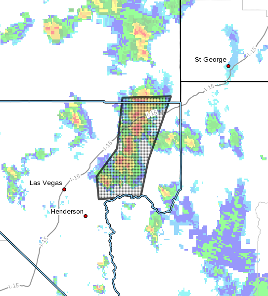
At 4:15 p.m., Doppler radar indicated heavy rain due to thunderstorms. These storms are currently over Snow Canyon State Park, Ivins and Santa Clara and are approaching St. George. Doppler radar indicates rainfall rates in excess of 1 inch per hour. Some flooding is anticipated in association with the storms, particularly in locations with poor drainage.
Some locations that will likely experience flooding include St George, Santa Clara, Ivins, Bloomington, Gunlock and Snow Canyon
State Park.
A flash flood warning has also been issued for Zion National Park in effect until 7:30 p.m. The Narrows and all slot canyons in the park are closed until two hours after the warning is over.
At 3 p.m. Saturday, the National Weather Service Doppler radar indicated an area of thunderstorms over northern Washington county between Goldstrike and Pine Valley moving southeast at 10 mph. Penny to nickel size hail and winds in excess of 40 mph will be possible.
Towns affected include New Harmony, Enterprise, Pinto, Pine Valley, Veyo and Goldstrike.
National Weather Service urges people to take shelter in a sturdy building. Torrential rainfall is also occurring with this storm and may lead to localized flooding. Do not drive your vehicle through flooded roadways.
Nevada
A flash flood Warning is in effect for northeastern Clark County in southern Nevada until 9 p.m. PDT.
At 5:55 PM PDT, Doppler radar indicated a line of thunderstorms producing heavy rain across northeast Clark County. Flash flooding is expected to begin shortly in Overton, Moapa Town, Moapa Valley, Echo Bay, Valley of Fire State Park, Callville Bay Campground, Overton Beach, Echo Bay Campground, Callville Bay, Logandale and Bunkerville.
This includes Interstate 15 in Nevada between mile markers 87 and 114.
Garfield/Kane County
At 7:59 p.m., trained weather spotters reported flash flooding on the Paria River near the Paria Townsite. This flash flood will continue down the Paria River and impact the area near US-89 between 9:30 and 10:00 p.m. Flash flooding will impact the Paria River from the Paria Townsite
to the Utah-Arizona border.
A flash flood warning for is in effect for south-central Garfield County and northeastern Kane County until 8 p.m.

At 3:29 p.m., Doppler radar indicated an area of thunderstorms producing heavy rain over Twentyfive Mile Wash, Harris Wash and Coyote Gulch in south central Garfield County and northeastern Kane County. Flash flooding is expected to occur in these areas.
Some locations that will experience flooding include Twentyfive Mile Wash, Harris Wash, Alvey Wash and Coyote Gulch all through the terminus at the Escalante River.
A flash flood warning for is also in effect for southwestern Kane County in effect until 8 p.m.
At 1:44 p.m., Doppler radar indicated a thunderstorm producing heavy rain over Kanab and bordering areas including drainages to the northeast of Kanab. Intense rainfall with radar estimates of ¼ inches in a matter of ten minutes has been observed.
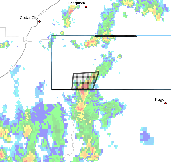
Up to 1 inch in the next hour is expected. Flash flooding is expected to begin shortly in Kanab, Kanab Creek and Lost Spring Wash due to the intense rain.
At 12:37 p.m., Doppler radar indicated a thunderstorm producing heavy rain over southern House Rock Valley Road near Wire Pass. Up to 1 inch of rain has already fallen, and flash flooding is expected to begin shortly.
Flash flooding is expected to impact Wire Pass, and flows are anticipated to continue downstream into Buckskin Gulch. Hikers or drivers through the area should take measures to ensure safety.
Precautions
Remain alert for flooding even in locations not receiving rain. Dry washes, streams and rivers can become raging killer currents in a matter of minutes, even from distant rainfall.
The National Oceanic and Atmospheric Association and the National Weather Service offer the following safety rules for flash flooding:
- When a flash flood warning is issued for your area or the moment you first realize that a flash flood is imminent, act quickly to save yourself. You may have only seconds.
- Most flood deaths occur in automobiles. Do not drive your vehicle into areas where the water covers the roadway. Flood waters are usually deeper than they appear. The road bed may not be intact under the water. Just 1 foot of flowing water is powerful enough to sweep vehicles off the road. If the vehicle stalls, abandon it immediately and seek higher ground. Rapidly rising water may engulf the vehicle and its occupants and sweep them away.
- Do not hike rivers and especially slot canyons while flash flood warnings are in place.
- Do not hike alone and always tell someone where you and your buddy and others are going.
- Get out of areas subject to flooding, including dips, low spots, canyons and washes.
- Avoid already flooded and high-velocity flow areas. Do not try to cross a flowing stream on foot where water is above your knees.
- Be especially cautious at night when it is harder to recognize flood dangers.
- Do not camp or park your vehicle along streams and washes, particularly during threatening conditions.
During any flood emergency, stay tuned to official weather reports via radio, television and social media. Cell phone users can also sign up to receive weather alerts as text messages. You can also follow St. George News and Cedar City News for weather alerts and updates relevant to Southern Utah.
Email: [email protected]
Twitter: @STGnews
Copyright St. George News, SaintGeorgeUtah.com LLC, 2018, all rights reserved.
Looks like it smacked Dammeron Valley with a fast moving wet willie. Just what they dont need!